
2021: Large-Scale Data Science Innovation Project for Water Resource Development
14/08/2024
The project has conducted in-depth data analysis by applying data science methodologies to support the assessment, monitoring, and prediction of water and weather conditions more efficiently. This is crucial for timely responses to the escalating situations of floods and droughts each year due to climate change. The project has expedited the creation of knowledge bases, research foundations, collaborative efforts, and the development of personnel in water resource data science. The goal is to apply this information effectively, leading to support for the national water resource management, both in normal conditions and during crises, with increased efficiency. In the year 2024, the following activities were undertaken:
Data Analysis to Enhance Water Management System
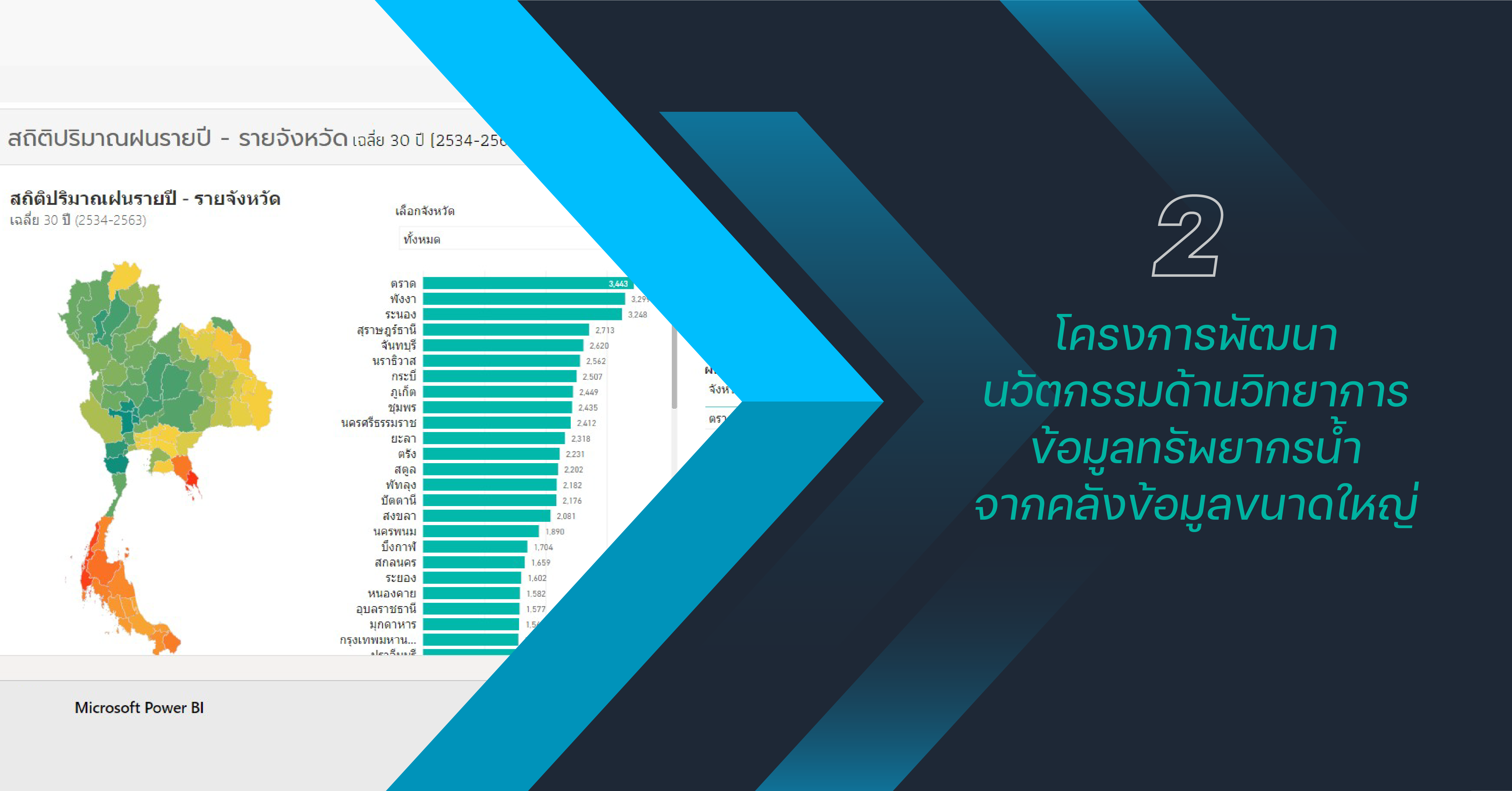
The project involves gathering rainfall, temperature, and water level data from automated telemetry stations of NHC members. The objective is to analyze patterns of issues that can be managed either in near-real-time or in a post-management, designed and created a database for controlling data quality, ensuring high-quality data for various water management systems. Moreover, the project has developed methods for analyzing and presenting 30-year statistical data (1991 – 2020) on rainfall at the provincial level on a monthly and yearly basis. This provides insights into the variations in rainfall quantities across provinces, supporting water management efforts.

Data Analysis for Establishing a Methodology to Control the Isotopic Stability Quality of Rainwater
The project involves collecting isotopic stability data of precipitation (in the year 2019-2020), examining and analyzing the preliminary data quality. The results will be disseminated through public systems, enabling users to utilize and further analyze the data for insights.

Image Data Analysis for Rainfall Monitoring and Flood Risk Prediction
The project involves designing and developing machine learning algorithms, including the creation of software to identify flood-prone areas based on historical event records. It combines unstructured data from past flood-affected areas, impacted by recorded rainfall, with its quantity data obtained from radar image processing. The program reads color values, and they are used to calculate rainfall amounts from the developed radar images. The analysis, conducted in 2023, aims to track and predict flood-prone areas, enhancing the understanding and forecasting of potential flood events.

The results from the analysis of radar images for tracking rainfall and predicting flood-prone areas, using rainfall radar images of 20 provinces from January 1, 2020, to June 30, 2021, as input data for testing, indicate an average accuracy of 73.42%. The highest accuracy of 91.2% was observed in February 2020, while the lowest accuracy of 52.17% was in July 2020. It is important to note that further improvement factors, such as the time period and data quantity used for analysis, should be considered for algorithm enhancement. These adjustments will contribute to the ongoing development of algorithms for more accurate analyses in the future.


